Geolocate

Euxton topographic map

Click on the map to display elevation.

About this map

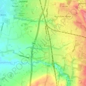
Name: Euxton topographic map, elevation, terrain.

Location: Euxton, Chorley, Lancashire, England, United Kingdom (53.65252 -2.72081 53.68191 -2.63997)

Average elevation: 50 m

Minimum elevation: 16 m

Maximum elevation: 97 m

Other topographic maps

Click on a map to view its topography, its elevation and its terrain.

Pincock

United Kingdom > England > Lancashire > Chorley > Euxton

Average elevation: 54 m

Gear up for your next adventure:

🧴Sunscreen SPF - Broad-spectrum sunscreen for outdoor activities
🚲Heavy Duty Bike Lock - Secure your bike at the trailhead or during stops
🧢Hiking Sun Hat - Wide-brimmed protection for exposed mountain ridges
Camping Groundsheet - Protect your tent from moisture and dirt
🩹Compact First Aid Kit - Pre-packed essentials for common trail injuries

As an Amazon Associate, this site earns from qualifying purchases at no extra cost to you.