Geolocate

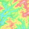
Harraton Cross topographic map

Click on the map to display elevation.

About this map

Name: Harraton Cross topographic map, elevation, terrain.

Location: Harraton Cross, Modbury, South Hams, Devon, Devon and Torbay, England, PL21 0SU, United Kingdom (50.33021 -3.87737 50.35021 -3.85737)

Average elevation: 82 m

Minimum elevation: 26 m

Maximum elevation: 138 m

Other topographic maps

Click on a map to view its topography, its elevation and its terrain.
Modbury

United Kingdom > England > Devon > South Hams > Modbury

Average elevation: 83 m

Modbury

United Kingdom > England > Devon > South Hams > Modbury

Average elevation: 83 m

Gear up for your next adventure:

🧦Hiking Liner Socks - Thin base layer to prevent friction and blisters
💡LED Camping Lantern - Illuminate your campsite with long-lasting lanterns
🥾Waterproof Hiking Boots - Essential footwear for rugged terrain and wet Canadian trails
⛺Bushcraft Tarp - Versatile emergency shelter or gear protection
🧥Thermal Fleece Jacket - Versatile insulation for changing mountain temperatures

As an Amazon Associate, this site earns from qualifying purchases at no extra cost to you.