Geolocate

Batak topographic map

Click on the map to display elevation.

About this map

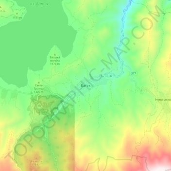
Name: Batak topographic map, elevation, terrain.

Location: Batak, Pazardzhik, 4580, Bulgaria (41.90297 24.17834 41.98297 24.25834)

Average elevation: 1,218 m

Minimum elevation: 843 m

Maximum elevation: 1,894 m

Gear up for your next adventure:

👟Trail Running Shoes - Agile footwear for fast-paced topographic exploration
🧢Hiking Hat - Sun-protective and breathable hats for long treks
🥾All-Terrain Hiking Boots - Versatile boots for varied hiking conditions
🥾Hiking Boots - Sturdy boots providing ankle support and traction on rugged trails
Camping Tent - Weather-resistant tents suitable for 2 to 6 people

As an Amazon Associate, this site earns from qualifying purchases at no extra cost to you.