Geolocate

Springville topographic map

Click on the map to display elevation.

About this map

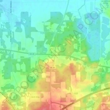
Name: Springville topographic map, elevation, terrain.

Location: Springville, LaPorte County, Indiana, United States (41.66532 -86.75669 41.70532 -86.71669)

Average elevation: 229 m

Minimum elevation: 201 m

Maximum elevation: 274 m

Other topographic maps

Click on a map to view its topography, its elevation and its terrain.

Michigan City

United States > Indiana > LaPorte County

Average elevation: 188 m

Westville

United States > Indiana > LaPorte County

Average elevation: 245 m

La Porte

United States > Indiana > LaPorte County

Average elevation: 249 m

Long Beach

United States > Indiana > LaPorte County

Average elevation: 184 m

Kingsbury

United States > Indiana > LaPorte County

Average elevation: 227 m

Michigan City

United States > Indiana > LaPorte County

Average elevation: 188 m

Fish Creek

United States > Indiana > LaPorte County > Fish Lake

Average elevation: 217 m

Wanatah

United States > Indiana > LaPorte County

Average elevation: 223 m

Gear up for your next adventure:

🛰️Satellite Messenger - Emergency communication for areas with no cell service
🕶️Polarized Sunglasses - Reduces glare from snow and water at high elevations
🥾Waterproof Hiking Boots - Boots keeping your feet dry in wet conditions
🩹Moleskin Blister Pads - Direct protection for painful foot pressure points
🧦Hiking Liner Socks - Thin base layer to prevent friction and blisters

As an Amazon Associate, this site earns from qualifying purchases at no extra cost to you.