
Make a donation
Gear up for your next adventure:
As an Amazon Associate, this site earns from qualifying purchases at no extra cost to you.
Dampierre-sous-Brou topographic map
Click on the map to display elevation.
Make a donation
Gear up for your next adventure:
As an Amazon Associate, this site earns from qualifying purchases at no extra cost to you.
About this map
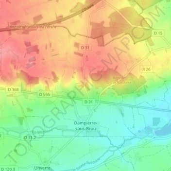
Name: Dampierre-sous-Brou topographic map, elevation, terrain.
Average elevation: 187 m
Minimum elevation: 150 m
Maximum elevation: 229 m
Make a donation
Gear up for your next adventure:
As an Amazon Associate, this site earns from qualifying purchases at no extra cost to you.
Other topographic maps
Click on a map to view its topography, its elevation and its terrain.
Make a donation
Gear up for your next adventure:
As an Amazon Associate, this site earns from qualifying purchases at no extra cost to you.
Le Cornet
France > Centre-Val de Loire > Eure-et-Loir > Saint-Lubin-de-la-Haye
Average elevation: 126 m
Butte Saint-Éloi
France > Centre-Val de Loire > Eure-et-Loir > Aunay-sous-Auneau
Average elevation: 150 m
Make a donation
Gear up for your next adventure:
As an Amazon Associate, this site earns from qualifying purchases at no extra cost to you.
Berchères-la-Maingot
France > Centre-Val de Loire > Eure-et-Loir > Berchères-Saint-Germain
Average elevation: 161 m
Saint-Sauveur
France > Centre-Val de Loire > Eure-et-Loir > Saint-Sauveur-Marville
Average elevation: 184 m
Villarceaux
France > Centre-Val de Loire > Eure-et-Loir > Les Villages Vovéens
Average elevation: 151 m
Make a donation
Gear up for your next adventure:
As an Amazon Associate, this site earns from qualifying purchases at no extra cost to you.
Make a donation
Gear up for your next adventure:
As an Amazon Associate, this site earns from qualifying purchases at no extra cost to you.
Minières
France > Centre-Val de Loire > Eure-et-Loir > Le Boullay-Thierry > Minières
Average elevation: 154 m
Make a donation
Gear up for your next adventure:
As an Amazon Associate, this site earns from qualifying purchases at no extra cost to you.
Make a donation
Gear up for your next adventure:
As an Amazon Associate, this site earns from qualifying purchases at no extra cost to you.
La Floride
France > Centre-Val de Loire > Eure-et-Loir > La Chapelle-du-Noyer
Average elevation: 130 m
Make a donation
Gear up for your next adventure:
As an Amazon Associate, this site earns from qualifying purchases at no extra cost to you.
Villevillon
France > Centre-Val de Loire > Eure-et-Loir > Les Autels-Villevillon
Average elevation: 187 m
Make a donation
Gear up for your next adventure:
As an Amazon Associate, this site earns from qualifying purchases at no extra cost to you.
La Borde des Bois
France > Centre-Val de Loire > Eure-et-Loir > La Bazoche-Gouet
Average elevation: 197 m
Make a donation
Gear up for your next adventure:
As an Amazon Associate, this site earns from qualifying purchases at no extra cost to you.
Saint-Maurice-de-Gasloup
France > Centre-Val de Loire > Eure-et-Loir > Saint-Maurice-Saint-Germain
Average elevation: 220 m
Make a donation
Gear up for your next adventure:
As an Amazon Associate, this site earns from qualifying purchases at no extra cost to you.
Merangle
France > Centre-Val de Loire > Eure-et-Loir > La Chapelle-Forainvilliers
Average elevation: 130 m
Make a donation
Gear up for your next adventure:
As an Amazon Associate, this site earns from qualifying purchases at no extra cost to you.
Make a donation
Gear up for your next adventure:
As an Amazon Associate, this site earns from qualifying purchases at no extra cost to you.
Make a donation
Gear up for your next adventure:
As an Amazon Associate, this site earns from qualifying purchases at no extra cost to you.
Make a donation
Gear up for your next adventure:
As an Amazon Associate, this site earns from qualifying purchases at no extra cost to you.
Château de Châteaudun
France > Centre-Val de Loire > Eure-et-Loir > Châteaudun
Average elevation: 126 m
Make a donation
Gear up for your next adventure:
As an Amazon Associate, this site earns from qualifying purchases at no extra cost to you.
Le Brosseron
France > Centre-Val de Loire > Eure-et-Loir > Saint-Arnoult-des-Bois
Average elevation: 184 m
L'Être des Bois
France > Centre-Val de Loire > Eure-et-Loir > La Bazoche-Gouet
Average elevation: 193 m
Make a donation
Gear up for your next adventure:
As an Amazon Associate, this site earns from qualifying purchases at no extra cost to you.
Make a donation
Gear up for your next adventure:
As an Amazon Associate, this site earns from qualifying purchases at no extra cost to you.
Le Petit Hanche
France > Centre-Val de Loire > Eure-et-Loir > Thimert-Gâtelles
Average elevation: 236 m
Ouencé
France > Centre-Val de Loire > Eure-et-Loir > Saint-Martin-de-Nigelles
Average elevation: 134 m
Make a donation
Gear up for your next adventure:
As an Amazon Associate, this site earns from qualifying purchases at no extra cost to you.
Parc Aquatique des Portes du Perche
France > Centre-Val de Loire > Eure-et-Loir > Fontaine-Simon > La Ferrière
Average elevation: 213 m
Moreaulieu
France > Centre-Val de Loire > Eure-et-Loir > Tremblay-les-Villages
Average elevation: 184 m
Make a donation
Gear up for your next adventure:
As an Amazon Associate, this site earns from qualifying purchases at no extra cost to you.
Le Coudray
France > Centre-Val de Loire > Eure-et-Loir > Saint-Martin-de-Nigelles
Average elevation: 125 m
Make a donation
Gear up for your next adventure:
As an Amazon Associate, this site earns from qualifying purchases at no extra cost to you.
Make a donation
Gear up for your next adventure:
As an Amazon Associate, this site earns from qualifying purchases at no extra cost to you.
Lieu Dit la Foret
France > Centre-Val de Loire > Eure-et-Loir > Louvilliers-lès-Perche
Average elevation: 188 m
Équillemont
France > Centre-Val de Loire > Eure-et-Loir > Auneau-Bleury-Saint-Symphorien
Average elevation: 145 m
Make a donation
Gear up for your next adventure:
As an Amazon Associate, this site earns from qualifying purchases at no extra cost to you.
La Chapelle des Bois
France > Centre-Val de Loire > Eure-et-Loir > La Bazoche-Gouet > La Chapelle des Bois
Average elevation: 193 m
L'Aumône
France > Centre-Val de Loire > Eure-et-Loir > Saint-Laurent-la-Gâtine
Average elevation: 134 m
Make a donation
Gear up for your next adventure:
As an Amazon Associate, this site earns from qualifying purchases at no extra cost to you.
Make a donation
Gear up for your next adventure:
As an Amazon Associate, this site earns from qualifying purchases at no extra cost to you.
Make a donation
Gear up for your next adventure:
As an Amazon Associate, this site earns from qualifying purchases at no extra cost to you.