Geolocate

Stone County topographic map

Click on the map to display elevation.

About this map

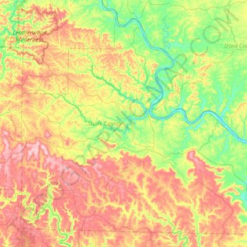
Name: Stone County topographic map, elevation, terrain.

Location: Stone County, Arkansas, United States (35.70498 -92.41879 36.12938 -91.83636)

Average elevation: 268 m

Minimum elevation: 83 m

Maximum elevation: 549 m

Other topographic maps

Click on a map to view its topography, its elevation and its terrain.

Cooper Point

United States > Arkansas > Stone County

Average elevation: 303 m

Gear up for your next adventure:

🪑Insulated Seat Pad - Protect your seat from cold rocks and wet logs
🛏️Sleeping Bag - Warm and compact sleeping bags for outdoor camping
🥾Mountaineering Boots - Supportive boots for climbing and high-altitude hiking
🩹Compact First Aid Kit - Pre-packed essentials for common trail injuries
Camping Groundsheet - Protect your tent from moisture and dirt

As an Amazon Associate, this site earns from qualifying purchases at no extra cost to you.