Geolocate

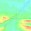
Cass topographic map

Click on the map to display elevation.

About this map

Name: Cass topographic map, elevation, terrain.

Location: Cass, Franklin County, Arkansas, United States (35.66758 -93.83936 35.70758 -93.79936)

Average elevation: 300 m

Minimum elevation: 207 m

Maximum elevation: 494 m

Other topographic maps

Click on a map to view its topography, its elevation and its terrain.
Ozark

United States > Arkansas > Franklin County

Average elevation: 167 m

Branch

United States > Arkansas > Franklin County

Average elevation: 148 m

Charleston

United States > Arkansas > Franklin County

Average elevation: 156 m

Gear up for your next adventure:

⛺Lightweight Camping Tent - Portable shelter optimized for Canadian backcountry camping
🧥Waterproof Jacket - Lightweight rain jackets for hiking and outdoor activities
🥾Hiking Gaiters - Protect legs and shoes from mud, snow, and debris
🥾Waterproof Hiking Boots - Boots keeping your feet dry in wet conditions
💡Portable Camping Lamp - Rechargeable lamp for campsite lighting

As an Amazon Associate, this site earns from qualifying purchases at no extra cost to you.