Geolocate

Mayangone topographic map

Click on the map to display elevation.

About this map
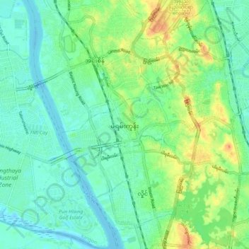
Name: Mayangone topographic map, elevation, terrain.

Location: Mayangone, Mayangon District, Yangon City, Yangon, Myanmar (16.82491 96.09468 16.90806 96.17849)

Average elevation: 12 m

Minimum elevation: -3 m

Maximum elevation: 37 m

Other topographic maps

Click on a map to view its topography, its elevation and its terrain.

Nyan Chaung

Myanmar > Yangon > Yangon City

Average elevation: 6 m

Daing Su

Myanmar > Yangon > Yangon City

Average elevation: 6 m

Daing Su

Myanmar > Yangon > Yangon City

Average elevation: 6 m

Htauk Kyant

Myanmar > Yangon > Yangon City

Average elevation: 17 m

Nyan Chaung

Myanmar > Yangon > Yangon City

Average elevation: 6 m

Zee Kone

Myanmar > Yangon > Yangon City

Average elevation: 11 m

Gear up for your next adventure:

🏕️Camping Hammock - Integrated protection for sleeping between trees
🥾Waterproof Trail Shoes - Shoes designed to handle wet terrain
🦯Trekking Poles - Reduced impact on joints for steep topographic climbs
🥾Trail Hiking Socks - Comfortable socks to prevent blisters and fatigue
🧥Softshell Hiking Jacket - The perfect balance of wind protection and breathability

As an Amazon Associate, this site earns from qualifying purchases at no extra cost to you.