
Kamanje topographic map
Click on the map to display elevation.
About this map
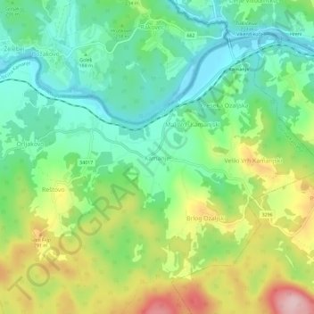
Name: Kamanje topographic map, elevation, terrain.
Location: Kamanje, Općina Kamanje, Karlovac County, 47282, Croatia (45.61317 15.37351 45.65317 15.41351)
Average elevation: 208 m
Minimum elevation: 123 m
Maximum elevation: 361 m
Other topographic maps
Click on a map to view its topography, its elevation and its terrain.
Oštarije
Two weather stations exist there: one at an elevation of 318 metres (1,043 ft) in the train station, and one at an elevation of 329 metres (1,079 ft) at Ravnice. The minimum recorded temperature for the winter of 2024–2025 was −11.7 °C (10.9 °F) at the train station, on February 20, and −13.8 °C (7.2…
Average elevation: 334 m
Jasenak
A weather station exists there at an elevation of 618 metres (2,028 ft). The minimum recorded temperature for the winter of 2024–2025 was −16.7 °C (1.9 °F), on February 20.
Average elevation: 884 m
Jasenak
A weather station exists there at an elevation of 618 metres (2,028 ft). The minimum recorded temperature for the winter of 2024–2025 was −16.7 °C (1.9 °F), on February 20.
Average elevation: 884 m
Grad Ogulin
Since records began in 1949, the highest temperature recorded at the local weather station at an elevation of 328 metres (1,076 ft) was 39.5 °C (103.1 °F), on 5 July 1950. The coldest temperature was −28.5 °C (−19.3 °F), on 17 February 1956.
Average elevation: 487 m