Geolocate

Castellaneta topographic map

Click on the map to display elevation.

About this map

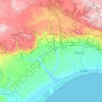
Name: Castellaneta topographic map, elevation, terrain.

Location: Castellaneta, Taranto, Apulia, 74011, Italy (40.44204 16.81047 40.72468 16.99507)

Average elevation: 161 m

Minimum elevation: -1 m

Maximum elevation: 457 m

Other topographic maps

Click on a map to view its topography, its elevation and its terrain.

Saturo

Italy > Apulia > Taranto > Leporano

Average elevation: 12 m

Marinara

Italy > Apulia > Taranto > Mottola

Average elevation: 261 m

Chiatona

Italy > Apulia > Taranto > Palagiano

Average elevation: 5 m

Gear up for your next adventure:

🧶550 Survival Paracord - Versatile utility cord for emergency repairs and rigging
🥾Mountain Hiking Boots - High-traction boots for rocky terrain
🔋Solar Power Bank - Keep your GPS and devices charged during long outdoor trips
🥾Mountain Hiking Shoes - Shoes with superior grip for mountainous terrain
Camping Tent - Weather-resistant tents suitable for 2 to 6 people

As an Amazon Associate, this site earns from qualifying purchases at no extra cost to you.