
Thank you for supporting this site ❤️
Make a donation
Make a donation
Gear up for your next adventure:
As an Amazon Associate, this site earns from qualifying purchases at no extra cost to you.
Llan-y-pwll topographic map
Click on the map to display elevation.
Thank you for supporting this site ❤️
Make a donation
Make a donation
Gear up for your next adventure:
As an Amazon Associate, this site earns from qualifying purchases at no extra cost to you.
About this map
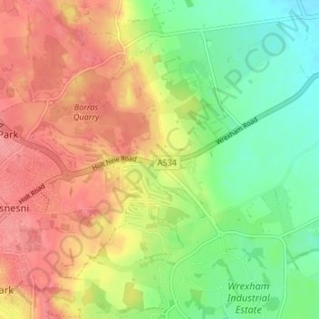
Name: Llan-y-pwll topographic map, elevation, terrain.
Location: Llan-y-pwll, Holt, Wrexham, Wales, LL13 9AD, United Kingdom (53.04096 -2.95812 53.08096 -2.91812)
Average elevation: 50 m
Minimum elevation: 12 m
Maximum elevation: 86 m
Thank you for supporting this site ❤️
Make a donation
Make a donation
Gear up for your next adventure:
As an Amazon Associate, this site earns from qualifying purchases at no extra cost to you.