Geolocate

Awang topographic map

Click on the map to display elevation.

About this map

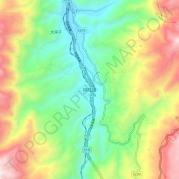
Name: Awang topographic map, elevation, terrain.

Location: Awang, Kunming, Yunnan, China (25.87998 103.21169 25.95998 103.29169)

Average elevation: 1,953 m

Minimum elevation: 1,394 m

Maximum elevation: 2,840 m

Other topographic maps

Click on a map to view its topography, its elevation and its terrain.

Panlong District

China > Yunnan > Kunming

Average elevation: 2,137 m

Shilin Yi Autonomous County

China > Yunnan > Kunming

Average elevation: 1,882 m

Shilin Yi Autonomous County

China > Yunnan > Kunming

Average elevation: 1,882 m

Dabanqiao Subdistrict

China > Yunnan > Kunming

Average elevation: 2,093 m

Tuodong Subdistrict

China > Yunnan > Kunming

Average elevation: 1,901 m

Gear up for your next adventure:

🥾Mountain Hiking Boots - High-traction boots for rocky terrain
🧥Packable Rain Jacket - Breathable waterproof layer for unpredictable weather
Lightweight Backpacking Tent - Compact tent for efficient hiking trips
🥾Trail Hiking Socks - Comfortable socks to prevent blisters and fatigue
🥾Approach Boots - Comfortable boots for hiking and climbing approaches

As an Amazon Associate, this site earns from qualifying purchases at no extra cost to you.