
ولسوالی ناور topographic map
Interactive map
Click on the map to display elevation.
About this map
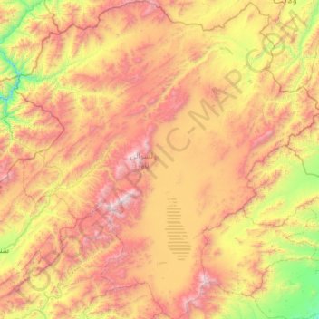
Name: ولسوالی ناور topographic map, elevation, terrain.
Location: ولسوالی ناور, Ghazni, Afghanistan (33.32697 67.24884 34.21913 68.28092)
Average elevation: 3,172 m
Minimum elevation: 2,075 m
Maximum elevation: 4,705 m
Other topographic maps
Click on a map to view its topography, its elevation and its terrain.
Sangi masha
Afghanistan > Ghazni > ولایت جاغوری
Sangi masha, ولایت جاغوری, Ghazni, Afghanistan
Average elevation: 2,846 m