Geolocate

Alpnach topographic map

Click on the map to display elevation.

About this map

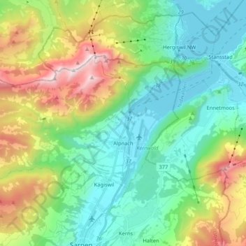
Name: Alpnach topographic map, elevation, terrain.

Location: Alpnach, Obwalden, Switzerland (46.91980 8.15000 46.98045 8.31097)

Average elevation: 920 m

Minimum elevation: 422 m

Maximum elevation: 2,113 m

Other topographic maps

Click on a map to view its topography, its elevation and its terrain.

Mörlialp

Switzerland > Obwalden > Giswil

Average elevation: 1,376 m

Lüssli

Switzerland > Obwalden > Engelberg

Average elevation: 1,311 m

Alpnachstad

Switzerland > Obwalden > Alpnach

Average elevation: 765 m

Gear up for your next adventure:

🥾Lightweight Hiking Shoes - Comfortable shoes for day hikes
🌬️Windproof Camp Stove - Efficient cooking even on exposed mountain peaks
🛏️Sleeping Bag - Warm and compact sleeping bags for outdoor camping
🧦Merino Wool Socks - Moisture-wicking comfort for long-distance hiking
🚲Bike Repair Kit - Essential tools for on-trail mechanical issues

As an Amazon Associate, this site earns from qualifying purchases at no extra cost to you.