Geolocate

Mestre topographic map

Click on the map to display elevation.

About this map

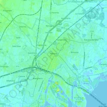
Name: Mestre topographic map, elevation, terrain.

Location: Mestre, Venice, Venezia, Veneto, 30170, Italy (45.45431 12.20181 45.53431 12.28181)

Average elevation: 4 m

Minimum elevation: -4 m

Maximum elevation: 13 m

Other topographic maps

Click on a map to view its topography, its elevation and its terrain.

Murano

Italy > Veneto > Venezia > Venice > Murano

Average elevation: 0 m

Canal Grande

Italy > Veneto > Venezia > Venice > Lido

Average elevation: 2 m

Burano

Italy > Veneto > Venezia > Venice > Burano

Average elevation: 0 m

Sant'Erasmo

Italy > Veneto > Venezia > Venice > Sant'Erasmo

Average elevation: 0 m

Gear up for your next adventure:

🥾Trail Running Shoes - Lightweight and durable shoes for trail running
👟Trail Running Shoes - Agile footwear for fast-paced topographic exploration
Camping Groundsheet - Protect your tent from moisture and dirt
🥾All-Terrain Hiking Boots - Versatile boots for varied hiking conditions
🧢Beanie Hat - Keep your head warm in cold weather

As an Amazon Associate, this site earns from qualifying purchases at no extra cost to you.