Geolocate

Ponzone topographic map

Click on the map to display elevation.

About this map

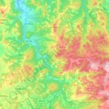
Name: Ponzone topographic map, elevation, terrain.

Location: Ponzone, Alessandria, Piedmont, Italy (44.50261 8.43203 44.61660 8.57650)

Average elevation: 451 m

Minimum elevation: 178 m

Maximum elevation: 819 m

Other topographic maps

Click on a map to view its topography, its elevation and its terrain.

Po

Italy > Piedmont > Alessandria > Coniolo

Average elevation: 146 m

Rosingo

Italy > Piedmont > Alessandria > Cerrina Monferrato

Average elevation: 234 m

Valle Scura

Italy > Piedmont > Alessandria > Brignano-Frascata

Average elevation: 396 m

Molini

Italy > Piedmont > Alessandria > Fraconalto

Average elevation: 624 m

Zanco

Italy > Piedmont > Alessandria > Villadeati

Average elevation: 241 m

Ciglione

Italy > Piedmont > Alessandria > Ponzone

Average elevation: 387 m

Gnocchetto

Italy > Piedmont > Alessandria > Ovada

Average elevation: 427 m

Mandrogne

Italy > Piedmont > Alessandria > Alessandria

Average elevation: 120 m

Incisa

Italy > Piedmont > Alessandria > Montacuto

Average elevation: 533 m

Gear up for your next adventure:

Camping Tent - Weather-resistant tents suitable for 2 to 6 people
🔦LED Headlamp - Hands-free lighting for early morning starts or late finishes
🛁Quick-Dry Microfiber Towel - Space-saving towel that dries rapidly on the move
🔦UV Flashlight - Detect minerals or specific insects in the dark
🛌Down Sleeping Bag - Superior warmth-to-weight ratio for cold nights

As an Amazon Associate, this site earns from qualifying purchases at no extra cost to you.