Geolocate

Odèn topographic map

Click on the map to display elevation.

About this map
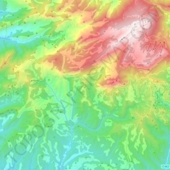
Name: Odèn topographic map, elevation, terrain.

Location: Odèn, Solsonès, Lleida, Catalonia, Spain (42.07344 1.32361 42.18475 1.55294)

Average elevation: 1,196 m

Minimum elevation: 539 m

Maximum elevation: 2,383 m

Other topographic maps

Click on a map to view its topography, its elevation and its terrain.

Canalda

Spain > Catalonia > Solsonès > Odèn

Average elevation: 1,288 m

la Coma

Spain > Catalonia > Solsonès > la Coma i la Pedra

Average elevation: 1,308 m

Su

Spain > Catalonia > Solsonès

Su, belongs to the municipality of Riner, in the comarca of Solsonès, vegueria of Comarques Centrals (Catalonia). Su is situated at an elevation of 726 meters above sea level.

Average elevation: 738 m

Su

Spain > Catalonia > Solsonès

Su, belongs to the municipality of Riner, in the comarca of Solsonès, vegueria of Comarques Centrals (Catalonia). Su is situated at an elevation of 726 meters above sea level.

Average elevation: 738 m

Gear up for your next adventure:

🕶️Polarized Sunglasses - Reduces glare from snow and water at high elevations
💧Collapsible Water Bottle - Space-saving water bottle for outdoor activities
🧢Beanie Hat - Keep your head warm in cold weather
🧥Waterproof Jacket - Lightweight rain jackets for hiking and outdoor activities
🧭GPS Tracker - Track your location in remote areas safely

As an Amazon Associate, this site earns from qualifying purchases at no extra cost to you.