Geolocate

Odèn topographic map

Click on the map to display elevation.

About this map

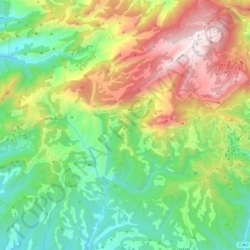
Name: Odèn topographic map, elevation, terrain.

Location: Odèn, Solsonès, Lleida, Catalonia, Spain (42.07344 1.32361 42.18475 1.55294)

Average elevation: 1,196 m

Minimum elevation: 539 m

Maximum elevation: 2,383 m

Other topographic maps

Click on a map to view its topography, its elevation and its terrain.

Su

Spain > Catalonia > Solsonès

Su, belongs to the municipality of Riner, in the comarca of Solsonès, vegueria of Comarques Centrals (Catalonia). Su is situated at an elevation of 726 meters above sea level.

Average elevation: 738 m

Su

Spain > Catalonia > Solsonès

Su, belongs to the municipality of Riner, in the comarca of Solsonès, vegueria of Comarques Centrals (Catalonia). Su is situated at an elevation of 726 meters above sea level.

Average elevation: 738 m

Canalda

Spain > Catalonia > Solsonès > Odèn

Average elevation: 1,288 m

la Coma

Spain > Catalonia > Solsonès > la Coma i la Pedra

Average elevation: 1,308 m

Gear up for your next adventure:

Backpacking Tent - Lightweight tent for long-distance hiking trips
💡Compact LED Flashlight - Powerful and portable flashlight for outdoor use
🧥Softshell Hiking Jacket - The perfect balance of wind protection and breathability
💧Filtered Water Bottle - Safe drinking water on the go
🎒Backpack Rain Cover - External shield to keep your entire pack dry

As an Amazon Associate, this site earns from qualifying purchases at no extra cost to you.