
Luleå kommun topographic map
Interactive map
Click on the map to display elevation.
About this map
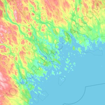
Name: Luleå kommun topographic map, elevation, terrain.
Location: Luleå kommun, Norrbotten County, Sweden (65.04128 21.33569 66.28314 23.39244)
Average elevation: 64 m
Minimum elevation: -4 m
Maximum elevation: 401 m
Other topographic maps
Click on a map to view its topography, its elevation and its terrain.
Muodoslompolo
Muodoslompolo, Pajala kommun, Norrbotten County, 984 85, Sweden
Average elevation: 238 m
Kalix kommun
Kalix kommun, Norrbotten County, Sweden
Average elevation: 33 m
Kiruna kommun
Kiruna kommun, Norrbotten County, Sweden
Average elevation: 618 m