Geolocate

Muodoslompolo topographic map

Click on the map to display elevation.

About this map

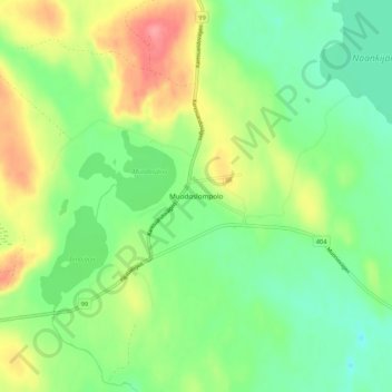
Name: Muodoslompolo topographic map, elevation, terrain.

Location: Muodoslompolo, Pajala kommun, Norrbotten County, 984 85, Sweden (67.92375 23.40555 67.96375 23.44555)

Average elevation: 238 m

Minimum elevation: 207 m

Maximum elevation: 287 m

Other topographic maps

Click on a map to view its topography, its elevation and its terrain.

Abisko nationalpark

Sweden > Norrbotten County

Permafrost is common in the national park, though permafrost at lower elevations is disappearing because of global warming and increased snowfall.

Average elevation: 740 m

Kalix kommun

Sweden > Norrbotten County

Average elevation: 33 m

Gear up for your next adventure:

🪜Heavy Duty Carabiners - Multi-use clips for securing gear to your backpack
🎒Backpack Rain Cover - External shield to keep your entire pack dry
🧦Crew Hiking Socks - Comfortable socks for long-distance hikes
💧Collapsible Water Bottle - Space-saving water bottle for outdoor activities
🥾Hiking Shorts - Breathable shorts suitable for summer hikes

As an Amazon Associate, this site earns from qualifying purchases at no extra cost to you.