
Hoensbroek topographic map
Interactive map
Click on the map to display elevation.
About this map
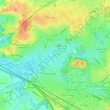
Name: Hoensbroek topographic map, elevation, terrain.
Location: Hoensbroek, Heerlen, Limburg, Niederlande (50.90127 5.89541 50.93661 5.94736)
Average elevation: 90 m
Minimum elevation: 69 m
Maximum elevation: 117 m
Other topographic maps
Click on a map to view its topography, its elevation and its terrain.