Geolocate

Ashkelon topographic map

Interactive map

Click on the map to display elevation.

About this map

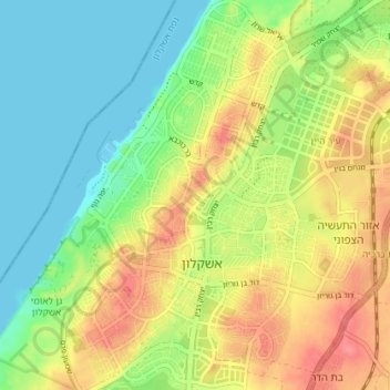
Name: Ashkelon topographic map, elevation, terrain.

Location: Ashkelon, Ashkelon Subdistrict, South District, Israel (31.64460 34.54782 31.70559 34.60656)

Average elevation: 31 m

Minimum elevation: 0 m

Maximum elevation: 69 m

Other topographic maps

Click on a map to view its topography, its elevation and its terrain.

Be’er-Sheva

Israel > South District

Average elevation: 290 m

Tamar Regional Council

Israel > South District

Average elevation: 272 m

Lehavim

Israel > South District

Average elevation: 316 m

Ashdod

Israel > South District

Average elevation: 31 m

Ashkelon

Israel > South District > Ashkelon

Average elevation: 38 m

Mt. Ira

Israel > South District

Average elevation: 498 m

Eilat

Israel > South District

Average elevation: 405 m

Sderot

Israel > South District

Average elevation: 84 m