Geolocate

Lehavim topographic map

Click on the map to display elevation.

About this map

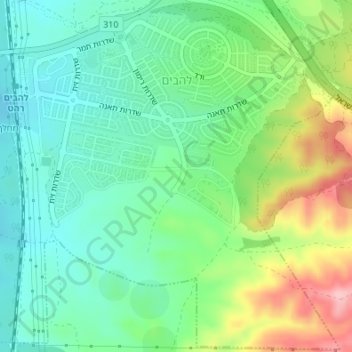
Name: Lehavim topographic map, elevation, terrain.

Location: Lehavim, Beersheba Subdistrict, South District, Israel (31.34815 34.78953 31.39349 34.82946)

Average elevation: 316 m

Minimum elevation: 247 m

Maximum elevation: 458 m

Other topographic maps

Click on a map to view its topography, its elevation and its terrain.

Arad

Israel > South District

The plan took into account topography and climate, with residential buildings constructed with large inner courtyards that offered protection from the desert sun and wind. High density residential areas were built first in order to create an urban milieu and shorten walking distances.

Average elevation: 579 m

Gvulot

Israel > South District > Eshkol Regional Council

Average elevation: 131 m

Ashkelon

Israel > South District > Ashkelon

Average elevation: 38 m

Ashdod

Israel > South District

Average elevation: 31 m

Gear up for your next adventure:

🥾Hiking Shoes - Durable and comfortable shoes for trail hiking
🐕Hiking Dog Pack - Let your canine companion carry their own water and food
🧦Outdoor Socks - Durable socks designed for hiking and outdoor sports
🛌Insulated Sleeping Pad - Critical thermal barrier between you and the cold ground
🛁Quick-Dry Microfiber Towel - Space-saving towel that dries rapidly on the move

As an Amazon Associate, this site earns from qualifying purchases at no extra cost to you.