Geolocate

Mundekulla topographic map

Click on the map to display elevation.

About this map

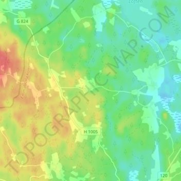
Name: Mundekulla topographic map, elevation, terrain.

Location: Mundekulla, Emmaboda kommun, Kalmar County, 361 95, Sweden (56.59440 15.39714 56.63440 15.43714)

Average elevation: 143 m

Minimum elevation: 122 m

Maximum elevation: 175 m

Other topographic maps

Click on a map to view its topography, its elevation and its terrain.

Nybro kommun

Sweden > Kalmar County

Average elevation: 109 m

Emmaboda kommun

Sweden > Kalmar County

Average elevation: 141 m

Hultsfreds kommun

Sweden > Kalmar County

Average elevation: 143 m

Hansa City

Sweden > Kalmar County

Average elevation: 7 m

Högsby kommun

Sweden > Kalmar County

Average elevation: 97 m

Store Hindsjön

Sweden > Kalmar County

Average elevation: 118 m

Mönsterås kommun

Sweden > Kalmar County

Average elevation: 26 m

Alen

Sweden > Kalmar County

Average elevation: 142 m

Emmaboda kommun

Sweden > Kalmar County

Average elevation: 141 m

Oskarshamns kommun

Sweden > Kalmar County

Average elevation: 63 m

Kalmar kommun

Sweden > Kalmar County

Average elevation: 28 m

Gear up for your next adventure:

🧥Packable Rain Jacket - Breathable waterproof layer for unpredictable weather
🧢Outdoor Cap - Protective cap for sun and rain during hikes
🧤Insulated Winter Gloves - Heavy-duty protection for sub-zero Canadian adventures
🚲MTB Frame Bag - Carry tools and maps directly on your bicycle frame
🧊Portable Cooler - Keep food and drinks cold during outdoor adventures

As an Amazon Associate, this site earns from qualifying purchases at no extra cost to you.