
Make a donation
Gear up for your next adventure:
As an Amazon Associate, this site earns from qualifying purchases at no extra cost to you.
Lam Ujong topographic map
Click on the map to display elevation.
Make a donation
Gear up for your next adventure:
As an Amazon Associate, this site earns from qualifying purchases at no extra cost to you.
About this map
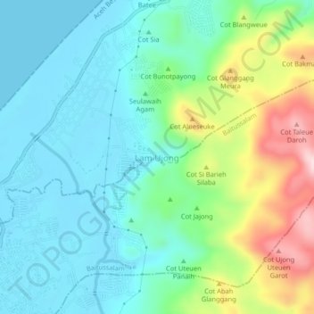
Name: Lam Ujong topographic map, elevation, terrain.
Location: Lam Ujong, Mesjid Raya, Aceh Besar, Aceh, Indonesia (5.60527 95.39817 5.64527 95.43817)
Average elevation: 81 m
Minimum elevation: 0 m
Maximum elevation: 304 m
Make a donation
Gear up for your next adventure:
As an Amazon Associate, this site earns from qualifying purchases at no extra cost to you.
Other topographic maps
Click on a map to view its topography, its elevation and its terrain.
Make a donation
Gear up for your next adventure:
As an Amazon Associate, this site earns from qualifying purchases at no extra cost to you.
Leupung
Indonesia > Aceh > Aceh Besar
Leupung -- also spelled "Leupueng", is a district in Aceh Besar regency, close to the city of Banda Aceh, the capital of the special territory of Aceh, Indonesia, on the island of Sumatra. Leupung is located at 5'31" North latitude and 95'15" East longitude at an elevation of 33 m. The population in 2004 was…
Average elevation: 465 m
Make a donation
Gear up for your next adventure:
As an Amazon Associate, this site earns from qualifying purchases at no extra cost to you.
Make a donation
Gear up for your next adventure:
As an Amazon Associate, this site earns from qualifying purchases at no extra cost to you.
Make a donation
Gear up for your next adventure:
As an Amazon Associate, this site earns from qualifying purchases at no extra cost to you.