Geolocate

Leupung topographic map

Click on the map to display elevation.

Leupung

Leupung -- also spelled "Leupueng", is a district in Aceh Besar regency, close to the city of Banda Aceh, the capital of the special territory of Aceh, Indonesia, on the island of Sumatra. Leupung is located at 5'31" North latitude and 95'15" East longitude at an elevation of 33 m. The population in 2004 was approximately 10,000; the district has been obliterated by the tsunami resulting from the 2004 Indian Ocean earthquake, being one of the towns closest to the earthquake's epicenter.

Wikipedia (CC-BY-SA 3.0)

About this map

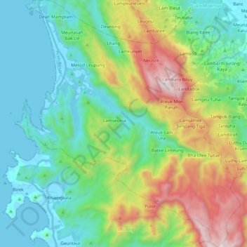
Name: Leupung topographic map, elevation, terrain.

Location: Leupung, Aceh Besar, Aceh, Sumatra, Indonesia (5.25006 95.22913 5.43674 95.39285)

Average elevation: 465 m

Minimum elevation: -4 m

Maximum elevation: 1,632 m

Other topographic maps

Click on a map to view its topography, its elevation and its terrain.

Seulawah

Indonesia > Aceh > Aceh Besar

Average elevation: 241 m

Teupin Batee

Indonesia > Aceh > Aceh Besar

Average elevation: 20 m

Gunung Batu

Indonesia > Aceh > Aceh Besar > Teureubeh

Average elevation: 183 m

Gurah

Indonesia > Aceh > Aceh Besar

Average elevation: 157 m

Sukamulia

Indonesia > Aceh > Aceh Besar

Average elevation: 391 m

Lamteuba Droi

Indonesia > Aceh > Aceh Besar

Average elevation: 1,012 m

Lampuuk

Indonesia > Aceh > Aceh Besar

Average elevation: 298 m

Lhok Nga

Indonesia > Aceh > Aceh Besar

Average elevation: 9 m

Lam Ujong

Indonesia > Aceh > Aceh Besar

Average elevation: 81 m

Gear up for your next adventure:

👟Leg Gaiters - Keep debris, mud, and snow out of your boots
💡LED Camping Lantern - Illuminate your campsite with long-lasting lanterns
Camping Coffee Maker - Brew fresh coffee anywhere on the topographic map
🥾Trekking Boots - Durable boots for long-distance trekking
🧦Hiking Socks - Moisture-wicking and comfortable socks for long hikes

As an Amazon Associate, this site earns from qualifying purchases at no extra cost to you.