Geolocate

Leersum topographic map

Click on the map to display elevation.

About this map
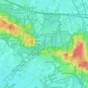
Name: Leersum topographic map, elevation, terrain.

Location: Leersum, Utrechtse Heuvelrug, Utrecht, Netherlands (51.99535 5.36362 52.05624 5.48757)

Average elevation: 15 m

Minimum elevation: 1 m

Maximum elevation: 72 m

Other topographic maps

Click on a map to view its topography, its elevation and its terrain.
Amersfoortse Berg

Netherlands > Utrecht > Amersfoort

Average elevation: 19 m

Breedeveen

Netherlands > Utrecht > Leersum

Average elevation: 15 m

Palestina

Netherlands > Utrecht > Amersfoort

Average elevation: 2 m

Cabauw

Netherlands > Utrecht

Average elevation: -1 m

Amerongse Berg

Netherlands > Utrecht > Amerongen

Average elevation: 34 m

Eembrugge

Netherlands > Utrecht > Baarn

Average elevation: 1 m

Gear up for your next adventure:

🛏️Sleeping Bag - Warm and compact sleeping bags for outdoor camping
📷Outdoor Action Camera - Capture high-elevation views and rugged adventures
👟Trail Running Shoes - Agile footwear for fast-paced topographic exploration
🔦UV Flashlight - Detect minerals or specific insects in the dark
🧥Ultralight Puffy Jacket - Maximum warmth that packs down to the size of an orange

As an Amazon Associate, this site earns from qualifying purchases at no extra cost to you.