
Make a donation
Gear up for your next adventure:
As an Amazon Associate, this site earns from qualifying purchases at no extra cost to you.
Zitouna topographic map
Click on the map to display elevation.
Make a donation
Gear up for your next adventure:
As an Amazon Associate, this site earns from qualifying purchases at no extra cost to you.
Zitouna
Zitouna est située dans le massif forestier de Collo, à 4 km du Mont Goufi, à l'Ouest de la wilaya de Skikda, en plein Sud du cap Bougaroun, à 593 mètres d’altitude entre mer et montagne au milieu d’une immense forêt de chênes-lièges de 25 000 hectares. Du fait de sa position, Zitouna est, par route, à 86 km de Skikda et à 14 km de Collo.
Make a donation
Gear up for your next adventure:
As an Amazon Associate, this site earns from qualifying purchases at no extra cost to you.
About this map
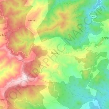
Name: Zitouna topographic map, elevation, terrain.
Location: Zitouna, Daïra Zitouna, Skikda, Algérie (36.94188 6.40820 37.03332 6.51345)
Average elevation: 522 m
Minimum elevation: 32 m
Maximum elevation: 1,172 m
Make a donation
Gear up for your next adventure:
As an Amazon Associate, this site earns from qualifying purchases at no extra cost to you.
Other topographic maps
Click on a map to view its topography, its elevation and its terrain.