Geolocate

Guixers topographic map

Click on the map to display elevation.

About this map

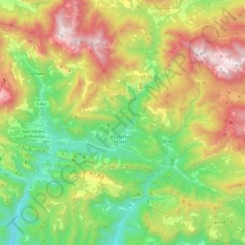
Name: Guixers topographic map, elevation, terrain.

Location: Guixers, Solsonès, Lleida, Catalonia, Spain (42.10310 1.52060 42.18387 1.73907)

Average elevation: 1,309 m

Minimum elevation: 639 m

Maximum elevation: 2,312 m

Other topographic maps

Click on a map to view its topography, its elevation and its terrain.

Su

Spain > Catalonia > Solsonès

Su, belongs to the municipality of Riner, in the comarca of Solsonès, vegueria of Comarques Centrals (Catalonia). Su is situated at an elevation of 726 meters above sea level.

Average elevation: 738 m

Su

Spain > Catalonia > Solsonès

Su, belongs to the municipality of Riner, in the comarca of Solsonès, vegueria of Comarques Centrals (Catalonia). Su is situated at an elevation of 726 meters above sea level.

Average elevation: 738 m

Canalda

Spain > Catalonia > Solsonès > Odèn

Average elevation: 1,288 m

la Coma

Spain > Catalonia > Solsonès > la Coma i la Pedra

Average elevation: 1,308 m

Gear up for your next adventure:

🥾Mountaineering Boots - Supportive boots for climbing and high-altitude hiking
🥾Hiking Gaiters - Protect legs and shoes from mud, snow, and debris
🧭GPS Outdoor Watch - Smart watch for navigation and fitness tracking in nature
🥾Hiking Boots - Sturdy boots providing ankle support and traction on rugged trails
🧭Orienteering Kit - Tools for map reading and navigation in the wild

As an Amazon Associate, this site earns from qualifying purchases at no extra cost to you.