
Thank you for supporting this site ❤️
Make a donation
Make a donation
Gear up for your next adventure:
As an Amazon Associate, this site earns from qualifying purchases at no extra cost to you.
Malefosse topographic map
Click on the map to display elevation.
Thank you for supporting this site ❤️
Make a donation
Make a donation
Gear up for your next adventure:
As an Amazon Associate, this site earns from qualifying purchases at no extra cost to you.
About this map
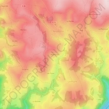
Name: Malefosse topographic map, elevation, terrain.
Average elevation: 924 m
Minimum elevation: 671 m
Maximum elevation: 1,049 m
Thank you for supporting this site ❤️
Make a donation
Make a donation
Gear up for your next adventure:
As an Amazon Associate, this site earns from qualifying purchases at no extra cost to you.
Other topographic maps
Click on a map to view its topography, its elevation and its terrain.
Oradour
France > Auvergne-Rhône-Alpes > Cantal > Neuvéglise-sur-Truyère
La commune d’Oradour s’étend sur 3 377 ha à une altitude moyenne de 940 m.
Average elevation: 971 m