
Nif topographic map
Click on the map to display elevation.
About this map
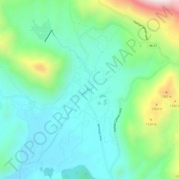
Name: Nif topographic map, elevation, terrain.
Location: Nif, Fethiye, Muğla, Aegean Region, Turkey (36.81247 29.15412 36.85247 29.19412)
Average elevation: 1,075 m
Minimum elevation: 865 m
Maximum elevation: 1,667 m
Other topographic maps
Click on a map to view its topography, its elevation and its terrain.
Oludeniz
Ölüdeniz offer a variety of diving opportunities with regard to its crystal clear waters and rich underwater caves and fauna. Scuba diving is the most popular underwater activity. Local diving agencies provide courses and required scuba diving licences. Snorkelling is another diving activity and many sites…
Average elevation: 541 m