Geolocate

Noel topographic map

Click on the map to display elevation.

About this map

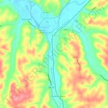
Name: Noel topographic map, elevation, terrain.

Location: Noel, McDonald County, Missouri, 64854, United States (36.51480 -94.50699 36.56001 -94.47221)

Average elevation: 287 m

Minimum elevation: 242 m

Maximum elevation: 342 m

Other topographic maps

Click on a map to view its topography, its elevation and its terrain.

Powell

United States > Missouri > McDonald County

Average elevation: 341 m

Gear up for your next adventure:

🧢Hiking Hat - Sun-protective and breathable hats for long treks
🥾Lightweight Hiking Boots - Boots for comfort and mobility on long hikes
🧢Hiking Sun Hat - Wide-brimmed protection for exposed mountain ridges
🏕️Camping Hammock - Integrated protection for sleeping between trees
🕶️Polarized Sunglasses - Reduces glare from snow and water at high elevations

As an Amazon Associate, this site earns from qualifying purchases at no extra cost to you.