Geolocate

Spencer topographic map

Click on the map to display elevation.

About this map

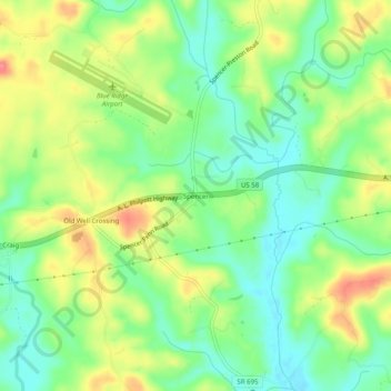
Name: Spencer topographic map, elevation, terrain.

Location: Spencer, Henry County, Virginia, 24165, United States (36.59986 -80.02727 36.63986 -79.98727)

Average elevation: 271 m

Minimum elevation: 240 m

Maximum elevation: 314 m

Other topographic maps

Click on a map to view its topography, its elevation and its terrain.

Oak Level

United States > Virginia > Henry County

Average elevation: 327 m

Sandy Level

United States > Virginia > Henry County > Sandy Level

Average elevation: 210 m

Stanleytown

United States > Virginia > Henry County

Average elevation: 259 m

Chatmoss

United States > Virginia > Henry County

Average elevation: 244 m

Laurel Park

United States > Virginia > Henry County

Average elevation: 228 m

Gear up for your next adventure:

🥤Collapsible Travel Cup - Saves space and weight in your mess kit
🧥Waterproof Hiking Jacket - Protect yourself from rain and wind while hiking
🧣Evaporative Cooling Towel - Beat the heat during intense summer climbs
💡Portable Camping Lamp - Rechargeable lamp for campsite lighting
💧Collapsible Water Bottle - Space-saving water bottle for outdoor activities

As an Amazon Associate, this site earns from qualifying purchases at no extra cost to you.