Geolocate

Alton topographic map

Click on the map to display elevation.

About this map

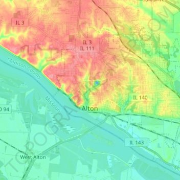
Name: Alton topographic map, elevation, terrain.

Location: Alton, Madison County, Illinois, 62002, United States (38.86338 -90.20901 38.93746 -90.08815)

Average elevation: 150 m

Minimum elevation: 120 m

Maximum elevation: 201 m

Other topographic maps

Click on a map to view its topography, its elevation and its terrain.

Alton

United States > Illinois > Madison County > Alton > Alton

Average elevation: 147 m

Gear up for your next adventure:

💡Solar Camping Lamp - Eco-friendly lighting for campsites
🛁Quick-Dry Microfiber Towel - Space-saving towel that dries rapidly on the move
Camping Tent - Weather-resistant tents suitable for 2 to 6 people
🛌Down Sleeping Bag - Superior warmth-to-weight ratio for cold nights
🏕️Camping Hammock - Integrated protection for sleeping between trees

As an Amazon Associate, this site earns from qualifying purchases at no extra cost to you.