Geolocate

Alton topographic map

Click on the map to display elevation.

About this map

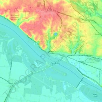
Name: Alton topographic map, elevation, terrain.

Location: Alton, Madison County, Illinois, 62002, United States (38.85086 -90.22431 38.93086 -90.14431)

Average elevation: 147 m

Minimum elevation: 120 m

Maximum elevation: 201 m

Gear up for your next adventure:

🥤Collapsible Travel Cup - Saves space and weight in your mess kit
🥘Camping Cookware Set - Compact nesting pots and pans for trail cooking
🕶️Polarized Sunglasses - Protect your eyes with durable polarized lenses
🚲Handlebar Phone Mount - View topographic-map.com live while cycling
🧢Outdoor Visor - Breathable visor for sunny hikes

As an Amazon Associate, this site earns from qualifying purchases at no extra cost to you.