Geolocate

Hambledon topographic map

Click on the map to display elevation.

About this map

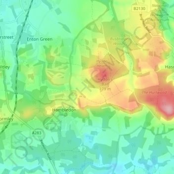
Name: Hambledon topographic map, elevation, terrain.

Location: Hambledon, Waverley, Surrey, England, United Kingdom (51.12129 -0.63757 51.16745 -0.57995)

Average elevation: 93 m

Minimum elevation: 39 m

Maximum elevation: 198 m

Gear up for your next adventure:

🛶Kayak Dry Bag - Waterproof storage for kayaking adventures
👟Trail Running Shoes - Agile footwear for fast-paced topographic exploration
🪜Heavy Duty Carabiners - Multi-use clips for securing gear to your backpack
🧤Thermal Hiking Gloves - Grip-enhanced gloves for cold-weather altitude trekking
🎒Backpack Rain Cover - External shield to keep your entire pack dry

As an Amazon Associate, this site earns from qualifying purchases at no extra cost to you.