Geolocate

Cagli topographic map

Click on the map to display elevation.

About this map

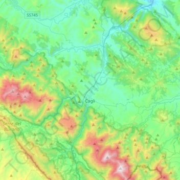
Name: Cagli topographic map, elevation, terrain.

Location: Cagli, Pesaro e Urbino, Marche, Italy (43.46979 12.50082 43.64808 12.81131)

Average elevation: 530 m

Minimum elevation: 119 m

Maximum elevation: 1,696 m

Other topographic maps

Click on a map to view its topography, its elevation and its terrain.

Fornace

Italy > Marche > Pesaro e Urbino > Cagli

Average elevation: 383 m

Colle

Italy > Marche > Pesaro e Urbino > Piobbico

Average elevation: 541 m

Lucrezia

Italy > Marche > Pesaro e Urbino

Average elevation: 68 m

San Lazzaro

Italy > Marche > Pesaro e Urbino > Fossombrone

Average elevation: 305 m

Gear up for your next adventure:

🧭Orienteering Kit - Tools for map reading and navigation in the wild
🧰Survival Kit - Essential gear for emergencies in the wilderness
🥾Waterproof Hiking Shoes - Durable shoes for wet and rugged trails
🩹Compact First Aid Kit - Pre-packed essentials for common trail injuries
🦶Anti-Blister Balm - Prevents friction and hotspots during long ascents

As an Amazon Associate, this site earns from qualifying purchases at no extra cost to you.