Geolocate

Colle topographic map

Click on the map to display elevation.

About this map

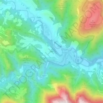
Name: Colle topographic map, elevation, terrain.

Location: Colle, Piobbico, Pesaro e Urbino, Marche, 61046, Italy (43.56973 12.48170 43.60973 12.52170)

Average elevation: 541 m

Minimum elevation: 324 m

Maximum elevation: 1,095 m

Gear up for your next adventure:

🧭Orienteering Kit - Tools for map reading and navigation in the wild
🪑Ultralight Camping Stool - Compact seating for rest stops during long hikes
🥾Trail Hiking Socks - Comfortable socks to prevent blisters and fatigue
🥾Mountain Hiking Shoes - Shoes with superior grip for mountainous terrain
🦟Insect Repellent - Keep mosquitoes and black flies away in wooded areas

As an Amazon Associate, this site earns from qualifying purchases at no extra cost to you.