
Make a donation
Gear up for your next adventure:
As an Amazon Associate, this site earns from qualifying purchases at no extra cost to you.
Great Dun Fell topographic map
Click on the map to display elevation.
Make a donation
Gear up for your next adventure:
As an Amazon Associate, this site earns from qualifying purchases at no extra cost to you.
Great Dun Fell
Under the Köppen climate classification, Great Dun Fell has a subpolar oceanic climate (Cfc), closely bordering both a subarctic climate (Dfc) under the 0 °C (32 °F) isotherm and an alpine tundra climate (ET) due to a July mean of exactly 10 °C (50 °F). The Met Office station publishes only temperature, wind and frost averages. The summers are cool due to elevation. Considering its elevation and a latitude of over 54 degrees, winters are relatively mild due to oceanic influences.
Make a donation
Gear up for your next adventure:
As an Amazon Associate, this site earns from qualifying purchases at no extra cost to you.
About this map
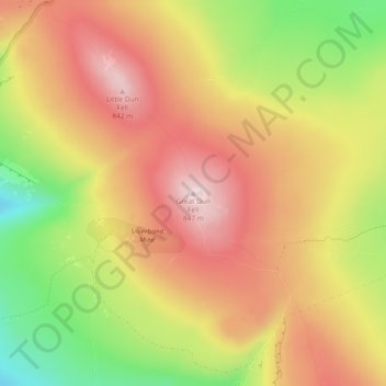
Name: Great Dun Fell topographic map, elevation, terrain.
Average elevation: 713 m
Minimum elevation: 526 m
Maximum elevation: 851 m
Make a donation
Gear up for your next adventure:
As an Amazon Associate, this site earns from qualifying purchases at no extra cost to you.