Geolocate

Lövåsen topographic map

Click on the map to display elevation.

About this map

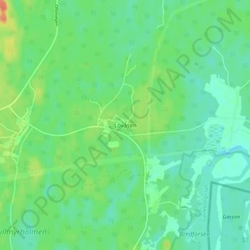
Name: Lövåsen topographic map, elevation, terrain.

Location: Lövåsen, Gävle kommun, Gävleborg County, 818 96, Sweden (60.42313 17.16968 60.46313 17.20968)

Average elevation: 56 m

Minimum elevation: 43 m

Maximum elevation: 85 m

Other topographic maps

Click on a map to view its topography, its elevation and its terrain.

Gran

Sweden > Gävleborg County > Gnarp District

Average elevation: 0 m

Ljusdals kommun

Sweden > Gävleborg County

Average elevation: 315 m

Disan

Sweden > Gävleborg County

Average elevation: 43 m

Hamra

Sweden > Gävleborg County

Average elevation: 437 m

Hamra

Sweden > Gävleborg County

Average elevation: 437 m

Hamra

Sweden > Gävleborg County

Average elevation: 437 m

Söderhamns kommun

Sweden > Gävleborg County

Average elevation: 67 m

Gnarp District

Sweden > Gävleborg County

Average elevation: 32 m

Hudiksvalls kommun

Sweden > Gävleborg County

Average elevation: 95 m

Gävle kommun

Sweden > Gävleborg County

Average elevation: 61 m

Gävle

Sweden > Gävleborg County

Average elevation: 28 m

Ovanåkers kommun

Sweden > Gävleborg County

Average elevation: 269 m

Hofors kommun

Sweden > Gävleborg County

Average elevation: 147 m

Gear up for your next adventure:

🥾Trekking Boots - Durable boots for long-distance trekking
🧥Softshell Jacket - Windproof and breathable jacket for hiking
🛌Down Sleeping Bag - Superior warmth-to-weight ratio for cold nights
🧦Hiking Socks - Moisture-wicking and comfortable socks for long hikes
💡Portable Camping Lamp - Rechargeable lamp for campsite lighting

As an Amazon Associate, this site earns from qualifying purchases at no extra cost to you.