
Make a donation
Gear up for your next adventure:
As an Amazon Associate, this site earns from qualifying purchases at no extra cost to you.
North West topographic map
Click on the map to display elevation.
Make a donation
Gear up for your next adventure:
As an Amazon Associate, this site earns from qualifying purchases at no extra cost to you.
About this map
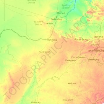
Name: North West topographic map, elevation, terrain.
Location: North West, South Africa (-28.11321 22.62898 -24.63675 28.29835)
Average elevation: 1,266 m
Minimum elevation: 850 m
Maximum elevation: 3,082 m
Make a donation
Gear up for your next adventure:
As an Amazon Associate, this site earns from qualifying purchases at no extra cost to you.
Other topographic maps
Click on a map to view its topography, its elevation and its terrain.
Durbanville
South Africa > Western Cape > City of Cape Town
Durbanville is situated in the northern suburbs of Cape Town, approximately 28 kilometres (17.4 mi) north-east of the city, bordered by Bellville to the south, Brackenfell to the south-east and Kraaifontein to the east. It lies at an altitude of between 100 m (328 ft) to 240 m (787 ft), in the vast rolling…
Average elevation: 157 m
Alice
South Africa > Eastern Cape > Amathole District Municipality > Nkonkobe Local Municipality > Alice
Average elevation: 586 m
Graaff-Reinet
South Africa > Sarah Baartman District Municipality > Camdeboo Local Municipality
Average elevation: 873 m
Make a donation
Gear up for your next adventure:
As an Amazon Associate, this site earns from qualifying purchases at no extra cost to you.
Hermanus
South Africa > Western Cape > Overberg District Municipality > Overstrand Local Municipality
Average elevation: 87 m
Sutherland
South Africa > Northern Cape > Namakwa District Municipality > Karoo Hoogland Local Municipality
Average elevation: 1,533 m
Dzanani
South Africa > Limpopo > Vhembe District Municipality > Makhado Local Municipality
Average elevation: 833 m
Make a donation
Gear up for your next adventure:
As an Amazon Associate, this site earns from qualifying purchases at no extra cost to you.
Flagstaff
South Africa > Eastern Cape > O.R. Tambo District Municipality > Ingquza Hill Local Municipality
Average elevation: 837 m
Cannon Rocks
South Africa > Eastern Cape > Sarah Baartman District Municipality > Ndlambe Local Municipality
Average elevation: 35 m
Bethelsdorp
South Africa > Eastern Cape > Nelson Mandela Bay Metropolitan Municipality
Average elevation: 85 m
Tierkloof
South Africa > Western Cape > West Coast District Municipality > Saldanha Bay Local Municipality
Average elevation: 92 m
Make a donation
Gear up for your next adventure:
As an Amazon Associate, this site earns from qualifying purchases at no extra cost to you.
Melk River
South Africa > Eastern Cape > Sarah Baartman District Municipality > Blue Crane Route Local Municipality
Average elevation: 699 m
Antjie Boom se Baken
South Africa > Northern Cape > Namakwa District Municipality > Hantam Local Municipality
Average elevation: 1,049 m
Make a donation
Gear up for your next adventure:
As an Amazon Associate, this site earns from qualifying purchases at no extra cost to you.
Jansenville
South Africa > Eastern Cape > Sarah Baartman District Municipality > Ikwezi Local Municipality
Average elevation: 448 m
Arniston
South Africa > Western Cape > Overberg District Municipality > Cape Agulhas Local Municipality
Average elevation: 13 m
Komani
South Africa > Eastern Cape > Chris Hani District Municipality > Lukhanji Local Municipality
Average elevation: 1,147 m
Coffee Bay
South Africa > Eastern Cape > O.R. Tambo District Municipality > King Sabata Dalindyebo Local Municipality
Average elevation: 40 m
Make a donation
Gear up for your next adventure:
As an Amazon Associate, this site earns from qualifying purchases at no extra cost to you.
Fernie
South Africa > Mpumalanga > Gert Sibande > Albert Luthuli Local Municipality
Average elevation: 1,449 m
De Vlugt
South Africa > Western Cape > Garden Route District Municipality > George Local Municipality
Average elevation: 457 m
Lusikisiki
South Africa > Eastern Cape > O.R. Tambo District Municipality > Ingquza Hill Local Municipality
Average elevation: 563 m
Make a donation
Gear up for your next adventure:
As an Amazon Associate, this site earns from qualifying purchases at no extra cost to you.
Germiston
South Africa > Gauteng > City of Ekurhuleni Metropolitan Municipality
Average elevation: 1,635 m
Cape St. Francis
South Africa > Eastern Cape > Sarah Baartman District Municipality > Kouga Local Municipality
Average elevation: 10 m
Matjiesfontein
South Africa > Western Cape > Central Karoo District Municipality > Laingsburg Local Municipality
Average elevation: 972 m
Cofimvaba
South Africa > Eastern Cape > Chris Hani District Municipality > Intsika Yethu Local Municipality
Average elevation: 997 m
Make a donation
Gear up for your next adventure:
As an Amazon Associate, this site earns from qualifying purchases at no extra cost to you.
Hillcrest
South Africa > KwaZulu-Natal > eThekwini Metropolitan Municipality
Hillcrest is situated in the Upper Highway Area of Durban, approximately 32 kilometres (20 mi) north-west of the city and is bordered by Gillitts and Everton to the east, Waterfall to the north-east and Botha's Hill and Assagay to the north-west. It lies at an altitude of approximately 680 m (2231 ft) above…
Average elevation: 625 m
Aston Bay
South Africa > Eastern Cape > Sarah Baartman District Municipality > Kouga Local Municipality > Aston Bay
Average elevation: 12 m
Make a donation
Gear up for your next adventure:
As an Amazon Associate, this site earns from qualifying purchases at no extra cost to you.
Durban North
South Africa > KwaZulu-Natal > eThekwini Metropolitan Municipality
Average elevation: 41 m
Richards Bay
South Africa > KwaZulu-Natal > King Cetswayo District Municipality > Richards Bay
Average elevation: 31 m
Hambrook
South Africa > KwaZulu-Natal > Uthukela District Municipality > Okhahlamba Local Municipality
Average elevation: 1,128 m
Make a donation
Gear up for your next adventure:
As an Amazon Associate, this site earns from qualifying purchases at no extra cost to you.
Kariega
South Africa > Eastern Cape > Nelson Mandela Bay Metropolitan Municipality
Average elevation: 89 m
Rainfall Dam
South Africa > Free State > Thabo Mofutsanyana District Municipality > Maluti-a-Phofung Local Municipality
Average elevation: 1,707 m
Underberg
South Africa > KwaZulu-Natal > Sisonke District Municipality > Kwa Sani Local Municipality > Underberg
Average elevation: 1,552 m
Make a donation
Gear up for your next adventure:
As an Amazon Associate, this site earns from qualifying purchases at no extra cost to you.
Botha
South Africa > Western Cape > Cape Winelands District Municipality > Witzenberg Local Municipality > Botha
Average elevation: 322 m
City of Johannesburg Metropolitan Municipality
South Africa > Gauteng > City of Johannesburg Metropolitan Municipality
Average elevation: 1,615 m
Rustenburg
South Africa > North West > Bojanala Platinum District Municipality > Rustenburg
Rustenburg has a humid subtropical climate (Köppen Cwa), with a relatively high degree of diurnal temperature variation due to the high elevation. It has very warm summers (from December to February) and mild winters (from June to August). Due to the altitude, summers are not quite as hot as one might expect.…
Average elevation: 1,217 m
Roodepoort
South Africa > Gauteng > City of Johannesburg Metropolitan Municipality > Roodepoort
Average elevation: 1,612 m
Make a donation
Gear up for your next adventure:
As an Amazon Associate, this site earns from qualifying purchases at no extra cost to you.
Riebeek-Wes
South Africa > Western Cape > West Coast District Municipality > Swartland Local Municipality > Riebeek-Wes
Average elevation: 262 m
Himalya Street Park
South Africa > Gauteng > City of Tshwane Metropolitan Municipality > Pretoria
Average elevation: 1,456 m
Swinburne
South Africa > Free State > Thabo Mofutsanyana District Municipality > Maluti-a-Phofung Local Municipality
Average elevation: 1,678 m
Franschhoek
South Africa > Western Cape > Cape Winelands District Municipality > Stellenbosch Local Municipality
Average elevation: 502 m
Make a donation
Gear up for your next adventure:
As an Amazon Associate, this site earns from qualifying purchases at no extra cost to you.
Fraserburg
South Africa > Northern Cape > Namakwa District Municipality > Karoo Hoogland Local Municipality
Fraserburg is situated at an altitude of 1,385 metres (4,544 ft) above sea level on a high Karoo plateau, north of the Nuweveld Mountains.
Average elevation: 1,268 m
Lime Acres
South Africa > Northern Cape > ZF Mgcawu District Municipality > Kgatelopele Local Municipality
Average elevation: 1,496 m
Wet Lands
South Africa > Western Cape > Cape Winelands District Municipality > Stellenbosch Local Municipality > Stellenbosch
Average elevation: 160 m
Make a donation
Gear up for your next adventure:
As an Amazon Associate, this site earns from qualifying purchases at no extra cost to you.