
Thank you for supporting this site ❤️
Make a donation
Make a donation
Gear up for your next adventure:
As an Amazon Associate, this site earns from qualifying purchases at no extra cost to you.
Maynas topographic map
Click on the map to display elevation.
Thank you for supporting this site ❤️
Make a donation
Make a donation
Gear up for your next adventure:
As an Amazon Associate, this site earns from qualifying purchases at no extra cost to you.
About this map
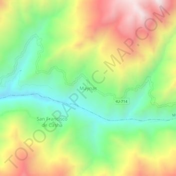
Name: Maynas topographic map, elevation, terrain.
Location: Maynas, Marías, Province of Dos de Mayo, Huánuco, Peru (-9.62564 -76.66688 -9.58564 -76.62688)
Average elevation: 3,841 m
Minimum elevation: 3,395 m
Maximum elevation: 4,439 m
Thank you for supporting this site ❤️
Make a donation
Make a donation
Gear up for your next adventure:
As an Amazon Associate, this site earns from qualifying purchases at no extra cost to you.