Geolocate

Sompting topographic map

Click on the map to display elevation.

About this map

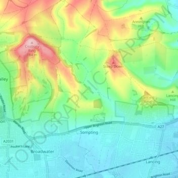
Name: Sompting topographic map, elevation, terrain.

Location: Sompting, Adur, West Sussex, England, United Kingdom (50.82098 -0.37154 50.87475 -0.32642)

Average elevation: 57 m

Minimum elevation: -2 m

Maximum elevation: 183 m

Other topographic maps

Click on a map to view its topography, its elevation and its terrain.

Lancing Ring

United Kingdom > England > West Sussex > Adur

Average elevation: 47 m

Shoreham-by-Sea

United Kingdom > England > West Sussex > Adur

Average elevation: 25 m

North Lancing

United Kingdom > England > West Sussex > Adur > Lancing

Average elevation: 24 m

Kingston Buci

United Kingdom > England > West Sussex > Adur

Average elevation: 17 m

Southwick

United Kingdom > England > West Sussex > Adur

Average elevation: 32 m

Southwick

United Kingdom > England > West Sussex > Adur

Average elevation: 32 m

Gear up for your next adventure:

💡Compact LED Flashlight - Powerful and portable flashlight for outdoor use
🥾Approach Boots - Comfortable boots for hiking and climbing approaches
🧦Merino Wool Socks - Moisture-wicking comfort for long-distance hiking
Tent Footprint - Protect tent floor and increase durability
🥾Trail Hiking Shoes - Durable shoes designed for rugged trails

As an Amazon Associate, this site earns from qualifying purchases at no extra cost to you.