
Make a donation
Gear up for your next adventure:
As an Amazon Associate, this site earns from qualifying purchases at no extra cost to you.
Bakum topographic map
Click on the map to display elevation.
Make a donation
Gear up for your next adventure:
As an Amazon Associate, this site earns from qualifying purchases at no extra cost to you.
Bakum
Bakum liegt am Südrand der Cloppenburger Geest. Das Gemeindegebiet wird durchzogen von einer Reihe von Geestbächen – u. a. dem Bakumer Bach, dem Schierenbach und dem Spredaer Bach –, die sämtlich über den Fladderkanal der Hase zuströmen. Die Landschaft wird von Ackerbauflächen bestimmt, die Topographie ist flach und bewegt sich auf Höhen zwischen 25 und 38 m über NHN.
Make a donation
Gear up for your next adventure:
As an Amazon Associate, this site earns from qualifying purchases at no extra cost to you.
About this map
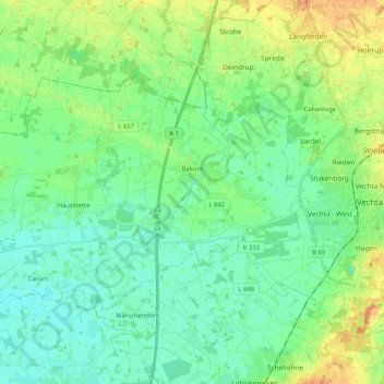
Name: Bakum topographic map, elevation, terrain.
Location: Bakum, Landkreis Vechta, Niedersachsen, 49456, Deutschland (52.69621 8.04632 52.77206 8.25255)
Average elevation: 35 m
Minimum elevation: 24 m
Maximum elevation: 58 m
Make a donation
Gear up for your next adventure:
As an Amazon Associate, this site earns from qualifying purchases at no extra cost to you.
Other topographic maps
Click on a map to view its topography, its elevation and its terrain.
Make a donation
Gear up for your next adventure:
As an Amazon Associate, this site earns from qualifying purchases at no extra cost to you.
Make a donation
Gear up for your next adventure:
As an Amazon Associate, this site earns from qualifying purchases at no extra cost to you.
Severinghausen
Deutschland > Niedersachsen > Landkreis Vechta > Neuenkirchen-Vörden
Average elevation: 59 m
Haverbeck
Deutschland > Niedersachsen > Landkreis Vechta > Damme > Langenteilen
Average elevation: 51 m
Rüschendorf
Deutschland > Niedersachsen > Landkreis Vechta > Damme > Rüschendorf
Average elevation: 50 m
Make a donation
Gear up for your next adventure:
As an Amazon Associate, this site earns from qualifying purchases at no extra cost to you.
Langenteilen
Deutschland > Niedersachsen > Landkreis Vechta > Damme > Langenteilen
Average elevation: 47 m
Nellinghof
Deutschland > Niedersachsen > Landkreis Vechta > Neuenkirchen-Vörden
Average elevation: 51 m
Make a donation
Gear up for your next adventure:
As an Amazon Associate, this site earns from qualifying purchases at no extra cost to you.