Geolocate

Anduze topographic map

Click on the map to display elevation.

About this map
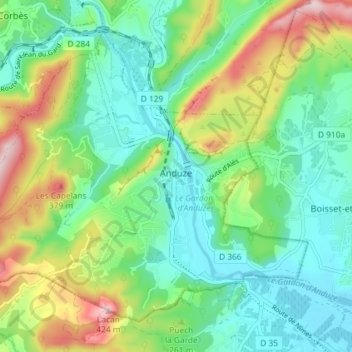
Name: Anduze topographic map, elevation, terrain.

Location: Anduze, Alès, Gard, Occitania, Metropolitan France, 30140, France (44.03251 3.94050 44.07551 4.01304)

Average elevation: 212 m

Minimum elevation: 114 m

Maximum elevation: 430 m

Other topographic maps

Click on a map to view its topography, its elevation and its terrain.
Dieusses

France > Occitania > Gard > Chambon

Average elevation: 399 m

Russan

France > Occitania > Gard > Sainte-Anastasie

Average elevation: 90 m

Hameau de Besson

France > Occitania > Gard > Bragassargues

Average elevation: 133 m

Cachar

France > Occitania > Gard > Saint-Jean-du-Gard

Average elevation: 312 m

Les Croisées

France > Occitania > Gard > Castillon-du-Gard

Average elevation: 41 m

Gear up for your next adventure:

🔭Compact Monocular - One-handed bird watching and trail spotting
🛏️Sleeping Bag - Warm and compact sleeping bags for outdoor camping
🧭GPS Handheld Device - Reliable GPS navigation for outdoor adventures
🧦Crew Hiking Socks - Comfortable socks for long-distance hikes
🥾Hiking Gaiters - Protect legs and shoes from mud, snow, and debris

As an Amazon Associate, this site earns from qualifying purchases at no extra cost to you.