
Winton topographic map
Click on the map to display elevation.
About this map
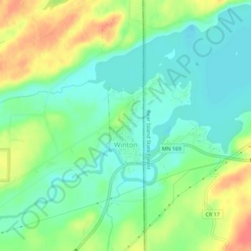
Name: Winton topographic map, elevation, terrain.
Location: Winton, Saint Louis County, Minnesota, 55796, United States (47.92418 -91.80356 47.93249 -91.79784)
Average elevation: 414 m
Minimum elevation: 394 m
Maximum elevation: 447 m
Other topographic maps
Click on a map to view its topography, its elevation and its terrain.
Chris Lake
United States > Minnesota > Saint Louis County > Pequaywan Township
Average elevation: 494 m
Embarrass
United States > Minnesota > Saint Louis County > Embarrass Township
Average elevation: 438 m
Tower Junction
United States > Minnesota > Saint Louis County > Breitung Township > Soudan
Average elevation: 437 m
Norway Creek
United States > Minnesota > Saint Louis County > Northeast St Louis
Average elevation: 424 m
Central Lakes
United States > Minnesota > Saint Louis County > Ellsburg Township
Average elevation: 408 m
Echo River
United States > Minnesota > Saint Louis County > Northeast St Louis
Average elevation: 393 m
Embarrass
United States > Minnesota > Saint Louis County > Embarrass Township
Average elevation: 438 m