Geolocate

Cadrete topographic map

Click on the map to display elevation.

About this map

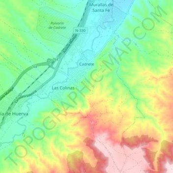
Name: Cadrete topographic map, elevation, terrain.

Location: Cadrete, Zaragoza, Aragon, Spain (41.51746 -0.98247 41.57811 -0.93366)

Average elevation: 405 m

Minimum elevation: 279 m

Maximum elevation: 623 m

Other topographic maps

Click on a map to view its topography, its elevation and its terrain.

Barranco de la Virgen

Spain > Aragon > Zaragoza > Zaragoza

Average elevation: 365 m

Huevo

Spain > Aragon > Zaragoza > Zaragoza

Average elevation: 321 m

Gear up for your next adventure:

💡Solar Camping Lamp - Eco-friendly lighting for campsites
🔪Outdoor Multitool - Versatile tool for repairs and food prep in the wild
🔥Camping Stove - Portable stoves to cook outdoors with ease
Camping Essentials - All-in-one gear for a comfortable camping trip
Backpacking Tent - Lightweight tent for long-distance hiking trips

As an Amazon Associate, this site earns from qualifying purchases at no extra cost to you.