Geolocate

Gresford topographic map

Click on the map to display elevation.

About this map

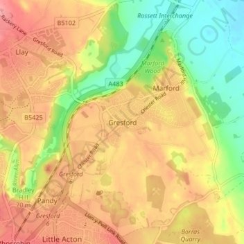
Name: Gresford topographic map, elevation, terrain.

Location: Gresford, Wrexham, Wales, LL12 8NB, United Kingdom (53.06551 -2.99199 53.10551 -2.95199)

Average elevation: 64 m

Minimum elevation: 15 m

Maximum elevation: 102 m

Other topographic maps

Click on a map to view its topography, its elevation and its terrain.

Gwersyllt

United Kingdom > Wales > Wrexham

Average elevation: 112 m

Penycae

United Kingdom > Wales > Wrexham

Average elevation: 350 m

Rhosddu

United Kingdom > Wales > Wrexham

Average elevation: 88 m

Bangor-on-Dee

United Kingdom > Wales > Wrexham

Average elevation: 30 m

Cefn

United Kingdom > Wales > Wrexham > Acrefair

Average elevation: 142 m

Gear up for your next adventure:

🛏️Camping Sleeping Mat - Comfortable mats for sleeping outdoors
🕶️Polarized Sunglasses - Reduces glare from snow and water at high elevations
🥾Lightweight Hiking Shoes - Comfortable shoes for day hikes
👖Convertible Hiking Pants - Zip-off legs to adapt to changing weather conditions
🥾Light Trekking Boots - Supportive boots for multi-day treks

As an Amazon Associate, this site earns from qualifying purchases at no extra cost to you.