Geolocate

New Castle topographic map

Click on the map to display elevation.

About this map

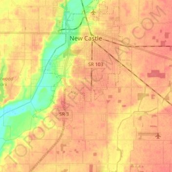
Name: New Castle topographic map, elevation, terrain.

Location: New Castle, Henry County, Indiana, 47362, United States (39.85573 -85.41013 39.94954 -85.33762)

Average elevation: 323 m

Minimum elevation: 289 m

Maximum elevation: 340 m

Other topographic maps

Click on a map to view its topography, its elevation and its terrain.

Messick

United States > Indiana > Henry County

Average elevation: 334 m

Westwood

United States > Indiana > Henry County

Average elevation: 319 m

Gear up for your next adventure:

🥾Trail Running Boots - Durable shoes designed for trail running
🥾Trail Hiking Socks - Comfortable socks to prevent blisters and fatigue
🛌Insulated Sleeping Pad - Critical thermal barrier between you and the cold ground
🩹Moleskin Blister Pads - Direct protection for painful foot pressure points
🧥Thermal Fleece Jacket - Versatile insulation for changing mountain temperatures

As an Amazon Associate, this site earns from qualifying purchases at no extra cost to you.