Geolocate

Moberly topographic map

Click on the map to display elevation.

About this map

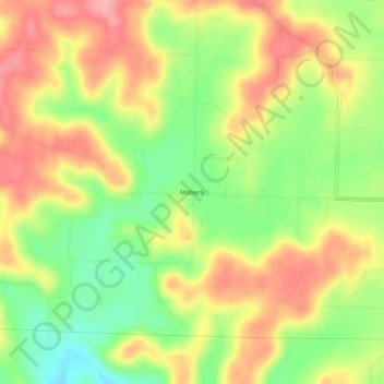
Name: Moberly topographic map, elevation, terrain.

Location: Moberly, Harrison County, Indiana, United States (38.24979 -86.22942 38.28979 -86.18942)

Average elevation: 205 m

Minimum elevation: 149 m

Maximum elevation: 255 m

Other topographic maps

Click on a map to view its topography, its elevation and its terrain.

Lanesville

United States > Indiana > Harrison County

Average elevation: 239 m

New Amsterdam

United States > Indiana > Harrison County

Average elevation: 151 m

New Middletown

United States > Indiana > Harrison County

Average elevation: 215 m

Crandall

United States > Indiana > Harrison County

Average elevation: 217 m

Laconia

United States > Indiana > Harrison County

Average elevation: 201 m

Gear up for your next adventure:

🌡️Emergency Mylar Blankets - Compact thermal protection for unexpected nights outdoors
💡LED Headlamp - Hands-free illumination for night hiking and camping
🥤Collapsible Travel Cup - Saves space and weight in your mess kit
🥾Trekking Poles - Adjustable trekking poles to reduce knee stress and improve stability
🧥Waterproof Pants - Keep dry during rainy hiking conditions

As an Amazon Associate, this site earns from qualifying purchases at no extra cost to you.